
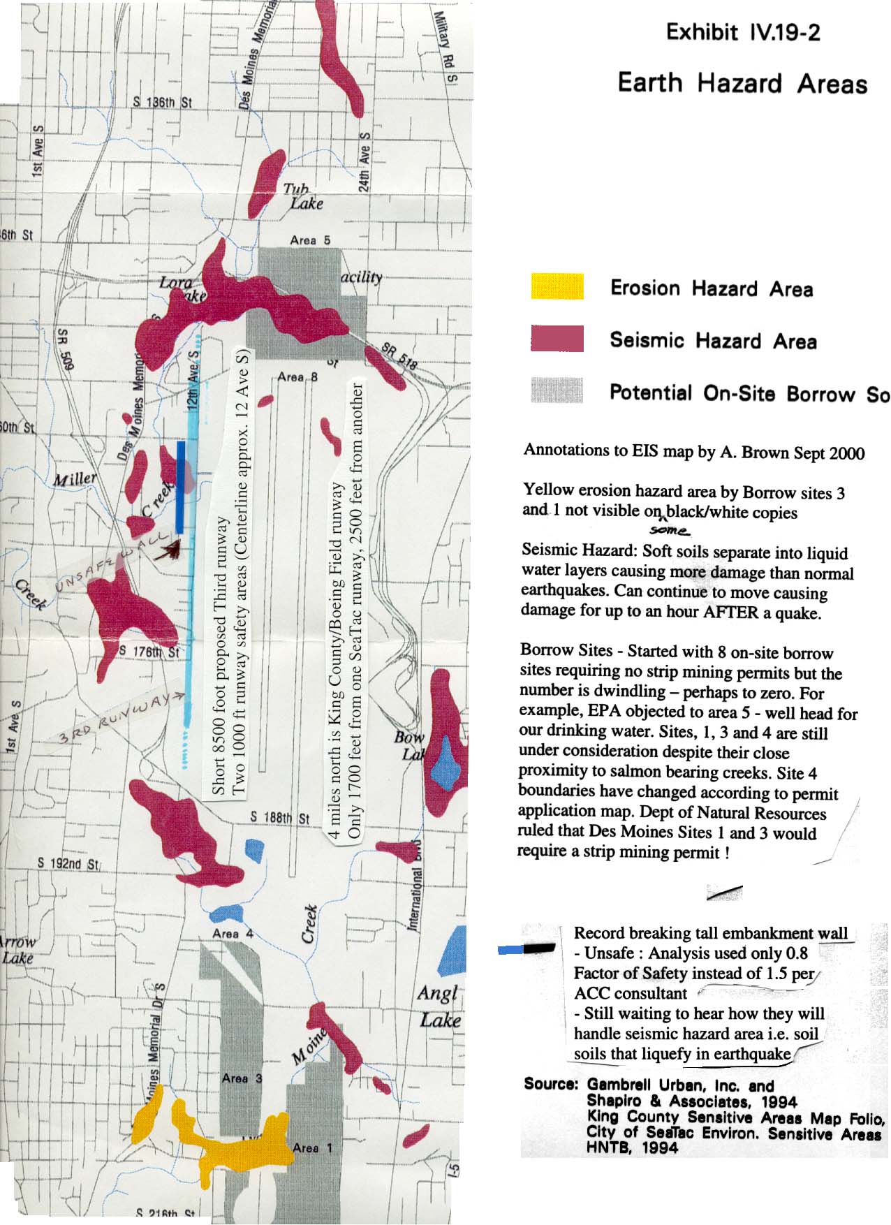
Sorry for quality of scanned SeaTac Master Plan EIS Exhibit IV.19-2 map Please check out the red areas that will liquefy in an earthquake. Note that both the record breaking wall and $4 billion plus dollar proposed third runway will be located in this dangerous area. Since this is a region with creeks and where some of the aquifer layers are close to the surface, large quanities of water are available to cause widespread liquefaction. More extensive damage than what was sustained at the Boeing Field/King County International Airport on 28 February 2001 in the 6.8 earthquake should be anticipated. Mud welled up through the large runway cracks making the runway unusable in those sections. However. since the proposed third runway will be adjacent to a cliff (world record tall embankement wall), that is holding back billions of pounds of fill, landslides that will shut down Highway 509 should also be anticipated. Whether the slides would also destroy the existing runways is unknown. See graphic of the tallest MSE wall at http://www.geocities.com/bzdiving/GreatWallofSeaTac.html See photo of 12 Street (centerline proposed third runway) at www.thirdrunway.homestead.com/photos.html and photos of embankment fill movement during the recent quake at Univ. of Washington liquefaction site -even has demo of building sinking at http://www.ce.washington.edu/~liquefaction/html/main.html The airport is the only place on the Univ. of WA web site map with a record of both large deep and shallow quakes (circle superimposed on square so it's easy to find on the map). Map at http://www.geophys.washington.edu/SEIS/PNSN/INFO_GENERAL/hi st.gif. Hence, the significance of February 2001 GeoSyntec comments regarding the inadequate earthquake analysis, unverified models, unconservative test parameters, and lack of adequate testing for soft soils that lead to liquefaction, etc. February 2001 GeoSyntec report also available at http://www.rcaanews.org/401_01geosys216.htm Government hazard map shows the 100 year flood area also to be in this same area http://www.esri.com/hazards/makemap.html and type in zip code 98148 (airport is between Highway 509 and 518 on map) . The following link may also work: USGS topographic map from the TopoZone! Zoom in and out to see the area. Red cross mark above radio tower is location of third runway, near the great wall. The above topographic map corresponds to latitude 47.4427º, longitude -122.3212º, Map center is UTM 10 551179E 5254365N , DES MOINES quad. Similar maps are available from the site with aerial photots listed below Aerial photos, http://terraserver.homeadvisor.msn.com. Search for Seattle-Tacoma International Airport or try this link http://terraserver.homeadvisor.msn.com/image.asp?S=13&T=1&X=3 45&Y=3284&Z=10&W=2 Sea-Tac and Boeing Field Earthquake Coverage is at Photos of Sea-Tac Control Tower damages are at http://maximus.ce.washington.edu/~nisqually/life/seatac_images.html Note broken windows and beam . Tower located 2,500 feet from liquefaction area. U of WA Seismic site http://www.geophys.washington.edu/SEIS/ Scroll down and then click on Letter sent to Army Corps of Engineering regarding this information - Word file named airportquakesMar2001web.doc (sorry has typos) New August 2001 - Latest seismic evaluation Considering in the Environmental Impact Statement says the clean air modeling solved global warming - they reduced pollution by adding aircraft- it comes as no surprise their earthquake modeling is yet another example of "garbage in - garbage out". Using the Port of Seattle consultant's modeling approach, two of the last three large earthquakes didn't happen. Of the following three quakes, which two shall we pretend didn't happen ? 1949 Mw 7.1 Olympia event, 1965 Mw 6.5 Seattle-Tacoma event, or Feb. 28, 2001 Nisqually event (Mw about 6.7). See page 11 last paragraph GeoSyntec-080601.doc for details. File is available at www.thirdrunway.homestead.com. The earthquake modeling just isn't adequate for that location's earthquake history and the type of soils present. The four tiered earthen wall, that will be a cliff from the perspective of the landing airplane, will not survive a large quake. Miller Creek, only about 50 feet away from it at the closest point, will get filled in from the inevitable slides. Imagine the liquefaction that occurred Feb 28 at Boeing field that shut down the runway for days but with a 150 -170 foot cliff beside it. Please check out the Home page of another related web site - www.thirdrunway.homestead.com. Also see links from there such as the ACC sites and RCAA sites for reports by experts. At least one expert's report includes landslide distance predictions. One of the Peer reviews of the Port's wall report discusses soft soils. Brown's Wetland permit comments submitted to US Army Corps of Engineer's have technical references on soft soils and their interaction with embankments as well as reference to ACC reports and Port funded Peer review. |
You are viewing the Hazard Map Page at http://www.nothirdrunway.homestead.com/quake.html Return to Home or check out a more complete site at www.thirdrunway.homestead.com |
Sorry for quality of scanned SeaTac Master Plan EIS Exhibit IV.19-2 map Please check out the red areas that will liquefy in an earthquake. Note that both the record breaking wall and $4 billion plus dollar proposed third runway will be located in this dangerous area. Since this is a region with creeks and where some of the aquifer layers are close to the surface, large quanities of water are available to cause widespread liquefaction. More extensive damage than what was sustained at the Boeing Field/King County International Airport on 28 February 2001 in the 6.8 earthquake should be anticipated. Mud welled up through the large runway cracks making the runway unusable in those sections. However. since the proposed third runway will be adjacent to a cliff (world record tall embankement wall), that is holding back billions of pounds of fill, landslides that will shut down Highway 509 should also be anticipated. Whether the slides would also destroy the existing runways is unknown. See graphic of the tallest MSE wall at http://www.geocities.com/bzdiving/GreatWallofSeaTac.html See photo of 12 Street (centerline proposed third runway) at www.thirdrunway.homestead.com/photos.html and photos of embankment fill movement during the recent quake at Univ. of Washington liquefaction site -even has demo of building sinking at http://www.ce.washington.edu/~liquefaction/html/main.html The airport is the only place on the Univ. of WA web site map with a record of both large deep and shallow quakes (circle superimposed on square so it's easy to find on the map). Map at http://www.geophys.washington.edu/SEIS/PNSN/INFO_GENERAL/hi st.gif. Hence, the significance of February 2001 GeoSyntec comments regarding the inadequate earthquake analysis, unverified models, unconservative test parameters, and lack of adequate testing for soft soils that lead to liquefaction, etc. February 2001 GeoSyntec report also available at http://www.rcaanews.org/401_01geosys216.htm Government hazard map shows the 100 year flood area also to be in this same area http://www.esri.com/hazards/makemap.html and type in zip code 98148 (airport is between Highway 509 and 518 on map) . The following link may also work: USGS topographic map from the TopoZone! Zoom in and out to see the area. Red cross mark above radio tower is location of third runway, near the great wall. The above topographic map corresponds to latitude 47.4427º, longitude -122.3212º, Map center is UTM 10 551179E 5254365N , DES MOINES quad. Similar maps are available from the site with aerial photots listed below Aerial photos, http://terraserver.homeadvisor.msn.com. Search for Seattle-Tacoma International Airport or try this link http://terraserver.homeadvisor.msn.com/image.asp?S=13&T=1&X=3 45&Y=3284&Z=10&W=2 Sea-Tac and Boeing Field Earthquake Coverage is at Photos of Sea-Tac Control Tower damages are at http://maximus.ce.washington.edu/~nisqually/life/seatac_images.html Note broken windows and beam . Tower located 2,500 feet from liquefaction area. U of WA Seismic site http://www.geophys.washington.edu/SEIS/ Scroll down and then click on Letter sent to Army Corps of Engineering regarding this information - Word file named airportquakesMar2001web.doc (sorry has typos) New August 2001 - Latest seismic evaluation Considering in the Environmental Impact Statement says the clean air modeling solved global warming - they reduced pollution by adding aircraft- it comes as no surprise their earthquake modeling is yet another example of "garbage in - garbage out". Using the Port of Seattle consultant's modeling approach, two of the last three large earthquakes didn't happen. Of the following three quakes, which two shall we pretend didn't happen ? 1949 Mw 7.1 Olympia event, 1965 Mw 6.5 Seattle-Tacoma event, or Feb. 28, 2001 Nisqually event (Mw about 6.7). See page 11 last paragraph GeoSyntec-080601.doc for details. File is available at www.thirdrunway.homestead.com. The earthquake modeling just isn't adequate for that location's earthquake history and the type of soils present. The four tiered earthen wall, that will be a cliff from the perspective of the landing airplane, will not survive a large quake. Miller Creek, only about 50 feet away from it at the closest point, will get filled in from the inevitable slides. Imagine the liquefaction that occurred Feb 28 at Boeing field that shut down the runway for days but with a 150 -170 foot cliff beside it. Please check out the Home page of another related web site - www.thirdrunway.homestead.com. Also see links from there such as the ACC sites and RCAA sites for reports by experts. At least one expert's report includes landslide distance predictions. One of the Peer reviews of the Port's wall report discusses soft soils. Brown's Wetland permit comments submitted to US Army Corps of Engineer's have technical references on soft soils and their interaction with embankments as well as reference to ACC reports and Port funded Peer review. |

This page was last updated on: September 30, 2001